|
Cadw Guidebook
Cilgerran Castle stands on a precipitous, craggy promontory overlooking the river Teifi where it merges with the Plysgog stream. The Teifi here is just at its tidal limit, so the castle was able to control both a natural crossing point and the passage of seagoing ships. We cannot be sure when this strong site was first fortified. It may be the same time as a Norman castle called 'Cenarth Bychan' from which we know, Nest, the spirited and beautiful wife of the Norman lord, Gerald of Windsor, ran off with Owain, son of the prince of Powys during a Welsh attack in 1109. Cilgerran is first mentioned by name in 1164, when the Lord Rhys captured the castle here. It was retaken by William Marshal, earl of Pembroke, in 1204, only to be taken again by the Welsh during Llywelyn the Great's campaigns in 1215. However, eight years later, William's son, another William, regained control, and it was probably he who built the imposing masonry castle we see today.
The form of the present castle may well reflect that of the earlier earthwork castle. The headland is cut off by a bank and ditch which encloses an outer ward, probably the original bailey. The ditch can still be seen, though much of it is cultivated as gardens. The outer gatehouse survives as low footings only and is of uncertain date and there may have been another, perhaps later, gatehouse on the site of the modern entrance. Much of the existing outer ward is a thin modern rebuild. The collapse of the original was caused by slate quarrying on the cliffs below.
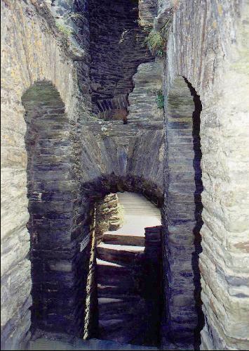
Some 20m beyond the outer defences, another ditch encloses the inner ward, which William fortified in stone with two formidable towers and a strong gatehouse. An interesting feature in the ditch is the sally-port, which consists of a door through the wall next to the east tower, and another in the outer ward wall, which together gave access to the sloping ground east of the castle to enable defenders to slip around to take attackers in the rear. A drawbridge crossed the deep ditch in front of the three-storey gatehouse. The outer part of the gatehouse has fallen, but the portcullis grooves and the draw-bar holes for the gate can still be seen at either end of the gate passage. There was a vaulted room, perhaps a chapel, over the gate, and above this, a passage in the curtain wall, defended with arrowslits, connected the gatehouse with the two round towers to its east. Finally, at the top of the wall, a battlemented wall-walk gave the castle's defenders a second access route to the towers.
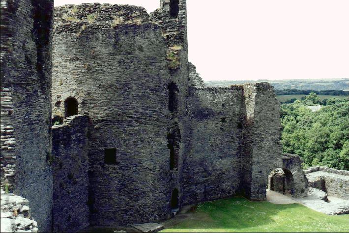
The strong, plain round towers protrude well beyond the curtain wall, and the outer defensive parts of their walls are much thicker than the inner sides. They are massive, unpretentious structures, designed with defence as the primary consideration. A series of arrowslits are the only openings on the outer side, to minimize the points of weakness against attack. Both towers have a ground floor and three upper storeys, the positions of which can be seen by the joist-holes for the timber floors and by the fireplaces. The eastern tower was entered at first-floor level from the courtyard by a door which led to a spiral stair. The ground-floor room had a separate entrance, and access to the upper floors was probably by a trapdoor. The west tower originally had a first-floor entrance reached by a stair from the inner ward; again, there must have been a trapdoor to give access to the ground floor which may have functioned as a strong-room or dungeon. Later, the ground-floor door was inserted and a spiral stair was put in to give access above. The cross-wall was then built so that the far side of the ground floor could continue in use as a strong-room.
The curtain wall and the remains of buildings along the north-east and north-west sides of the inner ward are a later build, probably dating to the second half of the 13th century, when the castle had passed through marriage from the Marshals first to the de Cantelupes, and then to the Hastings family. Some of the wall footings must belong to the hall and private apartments, and the kitchen lay against the western wall. A large square tower lay in the south-western corner. Near this is a round lime-kiln, and beyond, another well-defended sally-port to supplement the one in the outer gate.
In the 1370s an invasion from France was feared, and Edward III ordered that the now rather derelict Cilgerran be refortified. The north-west tower probably belongs to this period - it is clearly an addition, though so ruinous that it is difficult to date. After 1389, when the Hastings family died out, the castle passed to the crown, with which it was thenceforward closely associated. It may have been captured and held for a short time in 1405 during Owain Glyndwr's wars of independence; we know for certain that it was much damaged during the attack. But after that the castle's active military service came to an end. In the Tudor period, the Vaughan family were granted the castle by Henry VII, and they continued to occupy it until the early 17th century, when they built a new house nearby. The castle fell into ruin, but its picturesque setting made it an early favorite among tourists who, from the 18th century, could visit by boat from Cardigan.
|