Home | Main Menu | Castle Index | Historical Essays | Recommended Castles | What's New | Links
Whittington Castle 
Shropshire, England
 Map link for Whittington Castle
 |
Photographs & sketch below copyright © by John Northall.

Home | Main Menu | Castle Index | Historical Essays | Recommended Castles | What's New | Links

Shropshire, England
 Map link for Whittington Castle
 |
Photographs & sketch below copyright © by John Northall.

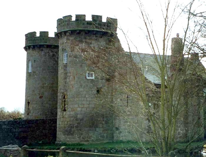
Above: The outer bailey gatehouse and a length of adjoining curtain wall. The battlements of the towers are a modern reconstruction. Although not recorded in the Domesday Book, local legend claims that a series of primitive castles has existed here since the 9th century. The present castle ruins date from 1221 when the fitz Warren family applied to King Henry III for permission to build a stone fortress. Originally, the castle had 7 towers, each about 18 metres high, with walls 3.7 metres thick and a drawbridge over 12 metres long. The fitz Warrens had a remarkable love/hate relationship with the English monarchy. Fulk fitz Warren is reputed to have quarrelled with Prince John, the future ill-fated king. The feud eventually caused fitz Warren to flee to France to avoid certain death. After years of exile, Fulk was granted a pardon and was able to return and repossess Whittington Castle.
The castle fell into decay after the Civil War and it recorded that one of the towers collapsed into the moat after a severe frost in 1760. The ruins were subsequently plundered for stone to surface roads and build houses. The present condition of the castle is a result of restoration and clearance work dating from 1967.
Whittington Castle Timeline
With acknowledgements to WS Atkins and the Whittington Castle Preservation Trust.
- Approximately 500 BC. The site was surrounded by triple banks and ditches, and those remaining to the north and west have recently been ascribed to the Iron Age. They can be seen in the aerial photographs at the Whittington Castle website.
- 600. Whittington was possibly the site of Llys Pengwern (Head of the Marsh), a capital of the Welsh kingdom of Powys. The description and presumed location of Llys Pengwern match this site in contrast to the more traditional Shrewsbury, which was not surrounded by a formidable marsh.
- 656. The Northumbrian Saxons destroyed Llys Pengwern, home of King Cynddylan of Powys, who was buried at nearby Eglwys Bassa (Baschurch).
- The manor of Whittington was granted to William of Peveril and a Norman motte and bailey earthwork castle was built within the northern end of the Iron Age fort.
- 1138. The castle was fortified for the empress Matilda against King Stephen
- 1173 The Norman leader Roger de Powys was given a grant towards the cost of repairing the castle by Henry II.
- 1204 King John granted the castle and manor to the Fitz-Warin family.
- 1221 The castle was rebuilt in stone by the Fitz-Warins under licence from King Henry III.
- 1223. The castle was besieged by Llywelyn ap Iorwerth of Gwynedd who was expanding his empire into Powys and the Welsh marches.
- 1265. Granted by Henry III to Llewelyn ap Gruffudd along with several other border strongholds.
- 1282. Restored to the Fulk-Warins after the final defeat of Llewelyn ap Gruffudd.
- 1643. The dilapidated castle was held for the King during the English civil war and was partially destroyed by the cannons of the opposing parliamentary forces. The damage was not repaired.
- 1960's onwards. Clearance and preservation by the Whittington Castle Preservation Trust.
Additional photographs of the castle
Below: The remaining inner gatehouse tower seen from the site of the north-western tower of the inner bailey. The footings of an older structure, probably the original hall-keep, can be seen to the right.
Below: Looking south along the ditch between the inner and outer baileys. The bridge to the inner bailey ran from the mound on the left to the gap between the twin gatehouse towers, only one of which is still standing.
Below: The remains of the inner bailey gateway. The tower to the right of the gate passage has been completely removed to provide stone for building material for local roads and houses. The strong defensive bank on the right hand side of the background appears to be the inner bank of the Iron Age fortress.
Below: Looking north from the outer bailey towards the motte. In common with other sites such as Warwick, the motte seems to have been left out of the revised stone defences. The extensive marsh, which protected the site, lies in the fields beyond the motte and despite modern drainage this area is still prone to seasonal flooding.
Below: The southern side of the inner bailey. The footings of a ruined tower are in the foreground and a postern gateway leading from the gate tower to the moat can be seen in the background. The inner bailey was formed by building revetment walls around the raised bailey earthwork and adding five towers that descend to ground level.
Follow this link to visit the Whittington Castle website
Learn more about the Welsh Marches

Home | Main Menu | Castle Index | Historical Essays | Recommended Castles | What's New | Links
Copyright © 2009 by John Northall and the Castles of Wales Website